
Garvellachs

The Garvellachs (Scottish Gaelic: Garbh Eileaich) or Isles of the Sea form a small archipelago in the Inner Hebrides of Scotland. Part of the Argyll and Bute council area, they lie in Firth of Lorne west of Lunga and northwest of Scarba and have been uninhabited "for many centuries".[1][a] The islands include Garbh Eileach, Dùn Chonnuill and Eileach an Naoimh.[3]
Overview
[edit]The waters surrounding the islands are extensively used for leisure sailing. Due to the array of separate tidal races produced by the underwater topography there are some treacherous stretches of water. These include the Grey Dog between Scarba and Lunga and the Gulf of Corryvreckan, between Scarba and Jura,[4] in which is located the infamous Corryvreckan whirlpool, which is the third-largest whirlpool in the world.[5]
The area is part of the Scarba, Lunga and the Garvellachs National Scenic Area, one of 40 such areas in Scotland, which are defined so as to identify areas of exceptional scenery and to ensure its protection by restricting certain forms of development.[6] The Scottish plant collector, Clara Winsome Muirhead surveyed the plant life of the islands and published The Flora of Easdale and the Garvellachs in 1962.
Garbh Eileach is the largest island in the group and extends to 142 ha (351 acres) and reaches a maximum elevation of 110 m (361 ft) above sea level.[7] The area of Eileach nan Naoimh is 56 ha (138 acres) and the maximum height 80 m (262 ft).[8] A’ Chùli lies between the two and is 20 ha (49 acres) in extent[9] with Dùn Chonnuill, the northernmost isle, being roughly half this size.[10]
Geology
[edit]
The Garvellachs are one of two main areas where the Late Precambrian Port Askaig Tillite formation is clearly exposed.[11] This rock sequence, around 700 million years old, is thought to have been formed during a period of extensive glaciation known as Snowball Earth. The Port Askaig tillite shows interbedded cycles of glacial and shallow marine sediments.[12] The significance of these deposits depends greatly upon their dating, which is difficult with glacial sediments. Until recently, the tillite could only be dated in reference to a bed 8 km stratigraphically higher that was placed at 600 Ma.[12] This allowed the Port Askaig formation to be tentatively correlated to the Sturtian glaciation, but it was still unknown whether it represented the advance or retreat of a Snowball Earth.[12]
Because there were few direct age constraints, the Port Askaig Formation had also been correlated with the younger Marinoan glaciation of approximately 645–635 Ma based largely on rhenium–osmium dating.[13]
In 2024, researchers published evidence from uranium–lead dating of zircons showing that the Port Askaig Formation could provide "eight new maximum depositional age constraints, including a key constraint on deglaciation (<662.7 ± 7.8 Ma)". They write that "this lithostratigraphic and stable isotope evidence ... suggests the Port Askaig Formation preserves a relatively complete record of the global Sturtian glaciation."[13] The study by researchers at University College London suggest the archipelago "may be the only place on Earth to have a detailed record of how the Earth entered one of the most catastrophic periods in its history."[14]
The research found that the sandstone of the Port Askaig Tillite was formed from Laurentian source rocks with ages ranging from c. 3700 to 660 Ma.[13]
Gallery
[edit]-
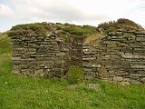 The monastery chapel, Eilach an Naoimh
 -
 Dùn Chonnuill from Garbh Eileach
 -
 1925 Ordnance Survey map with The Garvellachs at centre
 -
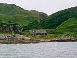 Bothy on Garbh Eileach
 -
 A' Chùli from Garbh Eileach


See also
[edit]References
[edit]- Notes
- Citations
- ^ Haswell-Smith 2004, pp. 67, 75.
- ^ Haswell-Smith 2004, pp. 75–76.
- ^ "Garvellachs (Isles of the Sea)". Gazetteer for Scotland. Retrieved 17 August 2024.
- ^ Haswell-Smith 2004, pp. 61–62.
- ^ "Corryvreckan Whirlpool". Gazetteer for Scotland. Retrieved 17 August 2024.
- ^ "National Scenic Areas". Scottish Natural Heritage. Retrieved 24 May 2018.
- ^ Haswell-Smith 2004, p. 75.
- ^ Haswell-Smith 2004, p. 67.
- ^ Rick Livingstone’s Tables of the Islands of Scotland (pdf) Argyll Yacht Charters. Retrieved 12 Dec 2011.
- ^ Ordnance Survey.
- ^ Spencer, A.M. (14 April 2011). "E18: The Late Precambrian Port Askaig Tillite in Scotland". In Hambrey, Michael J.; Harland, W. B. (eds.). Earth's Pre-Pleistocene Glacial Record. Cambridge University Press.
- ^ a b c Young, G.M. (1999). "Some aspects of the geochemistry, provenance and palaeoclimatology of the Torridonian of NW Scotland". Journal of the Geological Society. 156 (6): 1097–1111. Bibcode:1999JGSoc.156.1097Y. doi:10.1144/gsjgs.156.6.1097. S2CID 128600222.
- ^ a b c Rugen, Elias J.; Pastore, Guido; Vermeesch, Pieter; Spencer, Anthony M.; Webster, David; Smith, Adam G. G.; Carter, Andrew; Shields, Graham A. (2024). "Glacially influenced provenance and Sturtian affinity revealed by detrital zircon U–Pb ages from sandstones in the Port Askaig Formation, Dalradian Supergroup". Journal of the Geological Society. 181 (5): jgs2024-029. doi:10.1144/jgs2024-029.
- ^ Ghosh, Pallab (16 August 2024). "Scottish isles may solve mystery of 'Snowball Earth'". BBC. Retrieved 17 August 2024.
- Bibliography
- Haswell-Smith, Hamish (2004). The Scottish Islands. Edinburgh: Canongate. ISBN 978-1-84195-454-7.
- Ordnance Survey. OS Maps Online (Map). 1:25,000. Leisure.
External links
[edit]
|  | ||||||||||||||||
|
| |||||||||||||||||
| |||||||||||||||||
| |||||||||||||||||
| |||||||||||||||||
| |||||||||||||||||
| |||||||||||||||||
| |||||||||||||||||
56°14′N 5°47′W / 56.233°N 5.783°W
This article about a Site of Special Scientific Interest in Scotland is a stub. You can help Wikipedia by expanding it. |
This Argyll and Bute location article is a stub. You can help Wikipedia by expanding it. |