
Wakkanai
Wakkanai
稚内市 | |
|---|---|
 Clockwise from top:
| |
 Flag  Seal | |
 Location of Wakkanai in Hokkaido, highlighted in pink | |
 | |
 Wakkanai | |
| Coordinates: 45°24′56″N 141°40′23″E / 45.41556°N 141.67306°E | |
| Country | Japan |
| Region | Hokkaido |
| Prefecture | Hokkaido |
| Government | |
| • Mayor | Hiroshi Kudo (since May 2011) |
| Area | |
| • Total | 761.42 km2 (293.99 sq mi) |
| Population (July 31, 2024) | |
| • Total | 30,590 |
| • Density | 40/km2 (100/sq mi) |
| Time zone | UTC+9 (Japan Standard Time) |
| Phone number | 0162-23-6161 |
| Address | 3-13-15 Chūō, Wakkanai-shi, Hokkaido 097-8686 |
| Climate | Dfb |
| Website | Official website |
| Symbols | |
| Flower | Rosa rugosa |
| Tree | Sakura, rowan |


Wakkanai (稚内市, Wakkanai-shi, Ainu: ヤㇺワッカナィ Yam-wakka-nay meaning "cold water river" or more literally "cold river valley")[1] is a city located in Sōya Subprefecture, Hokkaido, Japan. It is the capital of Sōya Subprefecture. Wakkanai is home to Japan's first nursing home built inside the central train station of its city, a novel approach to caring for Japan's growing elderly population that has since been imitated in several other cities.[2]
As of 31 July 2024[update], the city had an estimated population of 30,590 in 17150 households, and a population density of 40 persons per km2.[3] The total area of the city is 761.42 km2 (293.99 sq mi).
Geography
[edit]Wakkanai is at the northern tip of Hokkaido, and faces the Sea of Japan to the west, Sōya Bay and the Sōya Strait to the north, and the Sea of Okhotsk to the east. Japan's northernmost point, Cape Sōya, is located in Wakkanai, which is on a peninsula jutting towards Sakhalin Island in Russia, which is 43 kilometers (27 miles) away. The city has a length of approximately 39 kilometers from north-to-south and 38 kilometers from east-to-west. The northernmost point is Benten-jima (45°31′35″N, 141°55′09″E), located northwest of Cape Sōya. This is the northernmost point of the land area currently under the effective control of Japan. The topography of the city consists of two hilly mountain ranges running north-to-south, and lowlands in between and at both ends of these. The eastern mountain range is called the "Sōya Hills" and is a periglacial landform that has been selected as a "Hokkaido Heritage Site". The lowlands between the western hills and the Sea of Japan are sand dunes and wetlands, and are part of the Rishiri-Rebun-Sarobetsu National Park.
- Rivers: Koetoi River
- Lakes: Ōnuma Lake
Surrounding municipalities
[edit]-
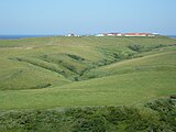 Sōya Hills
 -
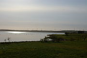 Onuma
Onuma -
 Cape Sōya
 -
 Bentenjima


Climate
[edit]Wakkanai has a humid continental climate (Köppen: Dfb) typical of Hokkaido but with strong influence of the ocean as island portions near the great land masses (such as the smaller islands of Nova Scotia),[4] with cold winters, warm summers and generally heavy precipitation from the Aleutian Low, whose winds hit the city direct from the Sea of Japan but with strong oceanic influence (46 °F). The winter is cold enough not to fall in a maritime climate (Cfb) and the summers although very mild for typical climate is warm enough not to fall into a subarctic climate (Dfc), both in the classification of Koppen.[5] The mean annual temperature, at 6.8 °C (44.2 °F), is the second lowest for a significant population centre in Japan after Nemuro. Snowfall at 6.6 metres (260 in), the third highest for a big city in Japan after Asahikawa and Aomori and one of the highest anywhere in the world. For comparison, Nain in Canada receives 194 inches (4.9 m) of snow.[citation needed]
The Aleutian Low also makes the sunshine hours the lowest of Japan's major population centres and in the winter the wind speeds are the highest in Japan with an average of 20.2 km/h (12.6 mph), which adds to the −4.7 °C (23.5 °F) cold of a typical winter day. The city's port is usually usable throughout the year, but does occasionally freeze in cold winters.[citation needed]
The highest temperature ever recorded in Wakkanai was 32.7 °C (90.9 °F) on 29 July 2021.[6] The coldest temperature ever recorded was −19.4 °C (−2.9 °F) on 30 January 1944.[7]
| Climate data for Wakkanai (1991−2020 normals, extremes 1938−present) | |||||||||||||
|---|---|---|---|---|---|---|---|---|---|---|---|---|---|
| Month | Jan | Feb | Mar | Apr | May | Jun | Jul | Aug | Sep | Oct | Nov | Dec | Year |
| Record high °C (°F) | 7.4 (45.3) |
9.3 (48.7) |
13.1 (55.6) |
20.2 (68.4) |
26.9 (80.4) |
26.8 (80.2) |
32.7 (90.9) |
31.6 (88.9) |
29.7 (85.5) |
23.5 (74.3) |
17.4 (63.3) |
11.5 (52.7) |
32.7 (90.9) |
| Mean maximum °C (°F) | 3.1 (37.6) |
4.1 (39.4) |
7.9 (46.2) |
14.9 (58.8) |
20.1 (68.2) |
22.6 (72.7) |
25.6 (78.1) |
26.4 (79.5) |
25.0 (77.0) |
19.6 (67.3) |
13.9 (57.0) |
6.6 (43.9) |
27.2 (81.0) |
| Mean daily maximum °C (°F) | −2.4 (27.7) |
−2.0 (28.4) |
1.6 (34.9) |
7.4 (45.3) |
12.4 (54.3) |
16.1 (61.0) |
20.1 (68.2) |
22.3 (72.1) |
20.1 (68.2) |
14.1 (57.4) |
6.3 (43.3) |
0.0 (32.0) |
9.7 (49.5) |
| Daily mean °C (°F) | −4.3 (24.3) |
−4.3 (24.3) |
−0.6 (30.9) |
4.5 (40.1) |
9.1 (48.4) |
13.0 (55.4) |
17.2 (63.0) |
19.5 (67.1) |
17.2 (63.0) |
11.3 (52.3) |
3.8 (38.8) |
−2.1 (28.2) |
7.0 (44.6) |
| Mean daily minimum °C (°F) | −6.4 (20.5) |
−6.7 (19.9) |
−3.1 (26.4) |
1.8 (35.2) |
6.3 (43.3) |
10.4 (50.7) |
14.9 (58.8) |
17.2 (63.0) |
14.4 (57.9) |
8.4 (47.1) |
1.3 (34.3) |
−4.2 (24.4) |
4.5 (40.1) |
| Mean minimum °C (°F) | −11.4 (11.5) |
−11.7 (10.9) |
−8.6 (16.5) |
−2.7 (27.1) |
1.5 (34.7) |
5.9 (42.6) |
10.4 (50.7) |
13.6 (56.5) |
9.1 (48.4) |
2.4 (36.3) |
−5.7 (21.7) |
−9.4 (15.1) |
−12.5 (9.5) |
| Record low °C (°F) | −19.4 (−2.9) |
−18.3 (−0.9) |
−17.4 (0.7) |
−8.0 (17.6) |
−2.2 (28.0) |
2.1 (35.8) |
6.4 (43.5) |
8.9 (48.0) |
3.5 (38.3) |
−4.4 (24.1) |
−11.4 (11.5) |
−16.0 (3.2) |
−19.4 (−2.9) |
| Average precipitation mm (inches) | 84.6 (3.33) |
60.6 (2.39) |
55.1 (2.17) |
50.3 (1.98) |
68.1 (2.68) |
65.8 (2.59) |
100.9 (3.97) |
123.1 (4.85) |
136.7 (5.38) |
129.7 (5.11) |
121.4 (4.78) |
112.9 (4.44) |
1,109.2 (43.67) |
| Average snowfall cm (inches) | 129 (51) |
105 (41) |
68 (27) |
9 (3.5) |
0 (0) |
0 (0) |
0 (0) |
0 (0) |
0 (0) |
1 (0.4) |
41 (16) |
122 (48) |
477 (188) |
| Average precipitation days (≥ 0.5 mm) | 23.8 | 20.0 | 16.3 | 11.3 | 10.8 | 10.2 | 9.5 | 10.6 | 12.6 | 16.3 | 20.2 | 23.9 | 185.4 |
| Average relative humidity (%) | 72 | 71 | 70 | 75 | 79 | 85 | 87 | 84 | 75 | 68 | 67 | 70 | 75 |
| Mean monthly sunshine hours | 40.6 | 74.7 | 137.5 | 173.5 | 181.6 | 154.6 | 142.7 | 150.7 | 172.1 | 134.6 | 55.9 | 28.4 | 1,446.9 |
| Source 1: Japan Meteorological Agency[8][7] | |||||||||||||
| Source 2: Météo Climat[9][10] | |||||||||||||
Demographics
[edit]Per Japanese census data, the population of Wakkanai is as shown below.
| Year | Pop. | ±% |
|---|---|---|
| 1940 | 25,375 | — |
| 1950 | 38,819 | +53.0% |
| 1960 | 51,113 | +31.7% |
| 1970 | 54,493 | +6.6% |
| 1980 | 53,471 | −1.9% |
| 1990 | 48,232 | −9.8% |
| 2000 | 43,774 | −9.2% |
| 2010 | 39,601 | −9.5% |
| 2020 | 33,563 | −15.2% |
History
[edit]Wakkanai was originally home to an Ainu population. A Japanese settlement was established in 1685 by Matsumae Domain as a trading post and key point for guarding northern Japan and the exploration of Sakhalin.[11]The settlement came under direct control of the Tokugawa shogunate from 1807 to 1821, and again from 1859, when Akita Domain was assigned to provide a garrison. The Akita garrison was replaced by Kanazawa Domain in 1870. After the Treaty of Saint Petersburg (1875), which exchanged Japanese claims on Sakhalin with the Kuril Islands, 841 Japanese settlers in Sakhalin were relocated to Wakkanai. A county office and headman's office established in Soya in 1879, which is regarded as the official foundation of the village of Wakkanai. In 1897, Sōya Subprefecture was established and Wakkanai was elevated to town status in 1901.
During World War II, the Imperial Japanese Navy used the harbor and port as a submarine base. Wakkanai was far enough north to be outside the range of American bombers and was safe from air attacks. Until the early to mid-1960s, the northern portion of the harbor remained divided by concrete sub-mooring pens. The large breakwater structure (which still exists) was actually a sub-repair facility. At the shore end there was a huge winching mechanism capable of hauling subs up into the partially enclosed structure where they could be repaired while completely out of the water. Built into the hills above the city there were several reinforced concrete bunker-type [aves where (anecdotally) they were used either to store ammunition and armament, or as air raid shelters for the civilian populace. History would suggest the former use, rather than the latter. During a re-build/renovation of the harbor sometime during the 1960s or 1970s, the harbor was cleared of the concrete pens and the machinery was removed from the breakwater structure which was reconfigured.
Wakkanai was elevated to city status in 1949. In 1955, Wakkanai annexed neighboring Soya village.
Government
[edit]Wakkanai has a mayor-council form of government with a directly elected mayor and a unicameral city council of 18 members. Wakkanai contributes one member to the Hokkaido Legislative Assembly. In terms of national politics, the city is part of the Hokkaido 12th district of the lower house of the Diet of Japan.
Economy
[edit]Wakkanai city's core industries are fisheries, agriculture, and tourism. As the largest city north of Asahikawa, it is home to national institutions such as the Japan Coast Guard, the Self-Defense Forces, the tax office, the courts, and the district prosecutor's office, as well as the Soya General Bureau. There are nine fishing ports.
Education
[edit]Wakkanai has nine public elementary schools, five public junior high schools and one combined elementary/junior high school operated by the city government and one public high school (Hokkaido Wakkanai High School) operated by the Hokkaido Board of Education. There is also one private high school. The Hokkaido government also operates one special education school for the handicapped.
Wakkanai Hokusei Gakuen University is located in the city.
Transportation
[edit]Airport
[edit]Wakkanai Airport is located in Wakkanai. There is a daily flight to New Chitose Airport near Sapporo and there is also a daily flight to Tokyo Haneda Airport.
Railway
[edit]- ■ Wakkanai - Minami-Wakkanai - Bakkai - Yūchi
The Sōya limited express runs once a day to and from Sapporo, while the Sarobetsu runs twice a day to and from Asahikawa, with a change of trains to either a Lilac or Kamui limited express service at Asahikawa required to reach Sapporo.
Seaports
[edit]
Heartland Ferry operates seasonal ferry service to Rebun Island and Rishiri Island. Ferry service to Korsakov on Sakhalin Island was terminated on September 18, 2015. Wakkanai mayor Hiroshi Kudo pledged to restore ferry service to Sakhalin and in 2016, the route resumed operation between the months of June and September of each year and is commercially operated by the Commonwealth of Dominica flagged vessel Penguin 33, which is a High-speed craft owned by Penguin International Limited and operated by Sakhalin Shipping Company.[12][13]
Sister cities and friendship cities
[edit]Sister city
[edit]Friendship cities
[edit]Domestic
[edit] Ishigaki, Okinawa (since 1987)[15]
- Makurazaki, Kagoshima (since 2012)
International
[edit] Nevelsk, Russia (since 1972)
- Korsakov, Russia (since 1992)
- Yuzhno-Sakhalinsk, Russia (since 2001)
Sister ports
[edit] Port of Anchorage, United States (since 1982)
Local attractions
[edit]- The Daisuke Matsuzaka Museum, dedicated to the baseball pitcher "Dice-K" and opened in 2008, is located in Wakkanai, which is his father's hometown.[16]
- Wakkanai Park, home to the Centennial Tower, commemorating the 100th anniversary of the founding of the city,[17] and the Hoppo Memorial Museum[18]
- Cape Sōya, home to a monument to the northernmost point in Japan[17]
- Hokumon Jinja, a Shinto shrine
- Wakkanai Onsen Dome, Japan's northernmost onsen.
Mascots
[edit]

Wakkanai's mascots are Rinzou-kun (りんぞうくん) and Dashinosuke (出汁之介).
- Rinzou-kun is a descendant of Mamiya Rinzō who explored the Strait of Tartary in what is now Russia.[19]
- Dashinosuke is a green harbor seal who is Rinzou-kun's assistant. His flippers and his tail resembled kelp. He loves fish and shellfish.[20]
External links
[edit] Wakkanai travel guide from Wikivoyage
 Media related to Wakkanai, Hokkaido at Wikimedia Commons
- Official Website (in Japanese)
| ||||||||||||
| ||||||||||||
| ||||||||||||
| ||||||||||||
| ||||||||||||
| ||||||||||||
| ||||||||||||
| ||||||||||||
| ||||||||||||
| ||||||||||||
| ||||||||||||
| ||||||||||||
| ||||||||||||
| ||||||||||||
| International | |
|---|---|
| National | |
| Geographic | |
- ^ アイヌ語地名リスト [Ainu Language Place Name List] (PDF) (in Japanese). Office of Ainu Measures Promotion, Department of Environment and Lifestyle, Hokkaido Government. Retrieved January 29, 2015.
- ^ "Every Human Intention by Dreux Richard: 9781101871119 | PenguinRandomHouse.com: Books". PenguinRandomhouse.com. Retrieved 2021-10-04.
- ^ "Wakkanai City official statistics" (in Japanese). Japan.
- ^ Muller, M. J. (2012-12-06). Selected climatic data for a global set of standard stations for vegetation science. Springer Science & Business Media. ISBN 9789400980402.
- ^ "Koppen Climate Classification" (PDF). Archived from the original (PDF) on 2019-04-12. Retrieved 2018-10-08.
- ^ "47401: Wakkanai (Japan)". ogimet.com. OGIMET. 29 July 2021. Retrieved 30 July 2021.
- ^ a b 観測史上1~10位の値(年間を通じての値). Japan Meteorological Agency. Retrieved 1 March 2022.
- ^ 気象庁 / 平年値(年・月ごとの値). Japan Meteorological Agency. Retrieved 1 March 2022.
- ^ "Météo climat stats for Wakkanai". Météo Climat. Retrieved 1 March 2022.
- ^ "Météo climat stats for Wakkanai". Météo Climat. Retrieved 1 March 2022.
- ^ History of Wakkanai
- ^ 稚内市. "Sakhalin regular line / Wakkanai-shi". www.city.wakkanai.hokkaido.jp.e.dh.hp.transer.com. Retrieved 2017-06-15.
- ^ "HSL 北海道サハリン航路株式会社". hs-line.com (in Japanese). Retrieved 2017-06-15.
- ^ International interaction of Wakkanai
- ^ Domestic Interaction of Wakkanai
- ^ ESPN.com article
- ^ a b Morrison, Geoffrey (2016-12-31). "Touring Wakkanai And The Northernmost Point Of Japan". Forbes. Retrieved 2020-03-02.
- ^ Nanda, Akshita (2016-11-06). "Exploring the northernmost tip of Japan". The Straits Times. Retrieved 2020-03-02.
- ^ "りんぞうくん(稚内市キャラクターデザイン)の使用について". Wakkanai.
- ^ "出汁之介 (北海道)". Yuru-Chara Grand Prix.